| . |  |
. |
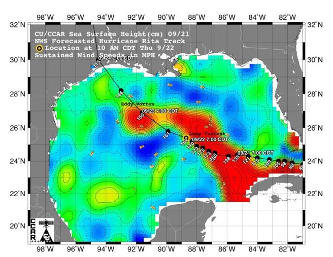
This sea surface height map of the Gulf of Mexico, with the Florida peninsula on the right and the Texas-Mexico Gulf Coast on the left, is based on altimeter data from four satellites including NASA's Topex/Poseidon and Jason. Red indicates a strong circulation of much warmer waters, which can feed energy to a hurricane. This area stands 35 to 60 centimeters (about 13 to 23 inches) higher than the surrounding waters of the Gulf. The actual track of a hurricane is primarily dependent upon steering winds, which are forecasted through the use of atmospheric models. However, the interaction of the hurricane with the upper ocean is the primary source of energy for the storm. Hurricane intensity is therefore greatly affected by the upper ocean temperature structure and can exhibit explosive growth over warm ocean currents and eddies. Eddies are currents of water that run contrary to the direction of the main current. According to the forecasted track through the Gulf of Mexico, Hurricane Rita will continue crossing the warm waters of a Gulf of Mexico circulation feature called the Loop Current and then pass near a warm-water eddy called the Eddy Vortex, located in the north central Gulf, south of Louisiana. The Jason satellite carries a dual-frequency radar altimeter. This instrument beams microwave pulses-at 13.6 and 5.3 Gigahertz, respectively-downward toward the Earth. To determine the ocean's height, the instrument precisely measures the time it takes for the microwave pulses to bounce off the surface and return to the spacecraft. This measure, multiplied by the speed of light, gives the range from the satellite to the ocean surface.
Related Links  Boulder CO (SPX) Sep 22, 2005
An advanced research weather model run by the National Center for Atmospheric Research (NCAR) is following Hurricane Rita to give scientists a taste of how well forecast models of the future may predict hurricane track, intensity, and important rain and wind features.
|
| ||||||||||
| The content herein, unless otherwise known to be public domain, are Copyright 1995-2016 - Space Media Network. All websites are published in Australia and are solely subject to Australian law and governed by Fair Use principals for news reporting and research purposes. AFP, UPI and IANS news wire stories are copyright Agence France-Presse, United Press International and Indo-Asia News Service. ESA news reports are copyright European Space Agency. All NASA sourced material is public domain. Additional copyrights may apply in whole or part to other bona fide parties. Advertising does not imply endorsement, agreement or approval of any opinions, statements or information provided by Space Media Network on any Web page published or hosted by Space Media Network. Privacy Statement All images and articles appearing on Space Media Network have been edited or digitally altered in some way. Any requests to remove copyright material will be acted upon in a timely and appropriate manner. Any attempt to extort money from Space Media Network will be ignored and reported to Australian Law Enforcement Agencies as a potential case of financial fraud involving the use of a telephonic carriage device or postal service. |
