| . |  |
. |
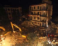
Berlin, Germany (SPX) May 11, 2009 How can we better protect rescue workers when they are deployed in a catastrophe - or find avalanche victims more efficiently? Fraunhofer researchers are currently working on a localization solution that combines satellite-based positioning with terrestrial guidance tools and situation-based sensor systems (such as integrated toxic gas sensors). The new system is intended to improve the coordination of deployed rescue professionals in the event of catastrophe, while ensuring their own safety at the same time. When handling an emergency, firefighters are exposed to a number of risks: noxious fumes, blocked escape paths, potential building collapse. The safety of emergency crews and the efficient locating of persons buried under the rubble are key issues, and not only in the event of a major catastrophe, such as the collapse of the Cologne Historic Archives on March 3, 2009. Emergency managers have to know exactly where their teams are, and if they might be exposed to poisonous gases. Modern localization systems provide excellent service in this situation. It is also the only optimal way to integrate rescue teams into emergency planning. By contrast, ineffective control station management, communication gaps and inadequate coordination of response strategies impair most extraordinarily time-critical rescue work. For this reason, experts are pursuing the positioning of rescue teams and needed rescue supplies and equipment with the aid of Global Navigation Satellite Systems (GNSS), which, in addition to GPS, also include Europe's Galileo and Russia's GLONASS. Fraunhofer scientists have established a Galileo lab for developing the new GNSS-based localization technologies. For their endeavors, researchers are using the Galileo satellite navigation system which - unlike GPS - is a civilian-controlled system. Absent military control, it is easier to implement special services for civil applications, such as rescue operations. Examples of this include "Search and Rescue" or "Safety of Life". At the Fraunhofer Galileo Lab, experts are working assiduously to provide services that localize individuals or goods in industry and the economy, transportation and mobility. With this goal in mind, scientists from nine Fraunhofer Institutes and the Fraunhofer Transport and Traffic Alliance have bundled their expertise. Currently, the researchers are concentrating on five fields of application: travel assistance, logistics,environmental applications such as emission monitoring, infrastructure construction and safety. "If you analyze different target groups, such as logistics, travel assistance, environmental monitoring or security services, it quickly becomes evident that the tasks are similar in terms of system architecture. Similar structures and content are always needed on similar end devices. For example, data indicating where an individual is located; sensors that deliver specific values such as toxic gas concentrations; or end devices that function as clients. Our objective is to offer a universal, service-oriented software architecture that works as a building-block system to allow configurable application profiles," explains project manager Werner Schonewolf of the Fraunhofer Institute for Production Systems and Design Technology IPK in Berlin. Take travel assistance for instance. When train passengers change trains at the station, a cell phone or PDA may soon be guiding them to the right connecting train without the passengers actually having to operate the devices. "This is possible through the context recognition in the end device. We connect the train schedule data with the positioning, so people can navigate themselves safely to the train, even in a labyrinthine train station," explains Schonewolf. "In catastrophic events, we connect sites with toxic gas sensors, and then can detect danger early on." The experts not only use Galileo data, but are also testing combined receivers for various satellite systems, since more precise navigation and ultimately better positioning - whether in the city or the wilderness - can be achieved with the collective total of all satellites in the skies. "We're developing our GNSS platform from the collective data gathered from GPS, GLONASS - the Russian satellite network - and Galileo," says Schonewolf. With data from 70 satellites in the sky, people and goods can be located much more precisely than ever before - even in deep canyons of urban areas, which were a challenge until now". Share This Article With Planet Earth
Related Links Fraunhofer-Gesellschaft Bringing Order To A World Of Disasters A world of storm and tempest When the Earth Quakes
 China says to finish quake reconstruction ahead of time
Beijing (AFP) May 8, 2009 China promised Friday to step up the pace of reconstruction in quake-devastated Sichuan province and said it would complete the process a year ahead of schedule. Mu Hong, a top planning official, said on the eve of the first anniversary of the 8.0-magnitude quake that more than 50 billion dollars had already been invested in projects in the region. Mu said that under initial plans from ... read more |
|
| The content herein, unless otherwise known to be public domain, are Copyright 1995-2009 - SpaceDaily. AFP and UPI Wire Stories are copyright Agence France-Presse and United Press International. ESA Portal Reports are copyright European Space Agency. All NASA sourced material is public domain. Additional copyrights may apply in whole or part to other bona fide parties. Advertising does not imply endorsement,agreement or approval of any opinions, statements or information provided by SpaceDaily on any Web page published or hosted by SpaceDaily. Privacy Statement |
 del.icio.us
 Digg
Digg Reddit
 YahooMyWeb
 Google