| . |  |
. |
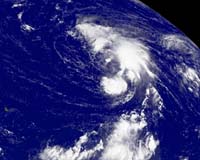
Miami (AFP) Sep 08, 2006 Hurricane Florence barreled closer to Bermuda Sunday, sending wave surges crashing against the tiny Atlantic island's coast less than a day ahead of its expected landfall, weather forecasters said. At 2100 GMT the center of the storm was about 185 miles (300 kilometers) south-southwest of Bermuda and headed toward the north at nearly 13 miles (20 kilometers) per hour, the US National Hurricane Center (NHC) said. The eye of the storm is expected to cross "very near" Bermuda early Monday, the NHC said in a statement. "Preparations to protect life and property should be rushed to completion," it said. Bermudan authorities closed the international airport, opened shelters and put the armed forces on alert. Tropical storm-force winds already were lashing the island, a British overseas territory with a population of 67,000. Maximum sustained winds were clocked near 90 miles (150 kilometers) per hour, packing higher gusts, the US meteorology center said. Tropical Storm Florence strengthened into a Category One hurricane early Sunday, becoming the second hurricane of the 2006 Atlantic hurricane season, after Ernesto. Florence is expected to power into a Category Two hurricane as it passes Bermuda. A Category Two storm on the Saffir-Simpson scale has sustained winds 96-110 miles (154-177 kilometers) per hour and can cause a storm surge of between six and eight feet (1.8-2.4 meters). Residents can expect downed trees, damage to some roofs and windows and considerable damage to mobile homes and piers, according to the NHC. Florence is not expected to make landfall in the United States as it proceeds northward Sunday, but rough seas were forecast along the eastern coast.
Strong quake shakes Gulf of Mexico region The epicenter of the 6.0 magnitude quake was located in the ocean some 450 kilometers (280 miles) south-southwest of Tampa, Florida, and some 530 kilometers (330 miles) southeast of New Orleans, Louisiana. The quake struck just before 1456 GMT, the service said, updating and revising an earlier statement. "This earthquake was felt in parts of (the southern US states of) Florida, Georgia and Alabama" as well as Louisiana, the USGS said in a statement. "No reports of damage or casualties have been received at this time." The quake was centered "beneath the Gulf of Mexico, well distant from the nearest active plate boundary. "Such 'midplate' earthquakes are much less common than earthquakes occurring on faults near plate boundaries, and most probably represent the release of long-term tectonic stresses that ultimately originate from forces applied at the plate boundary," the USGS said. The statement described the quake as "the largest of more than a dozen shocks that have been instrumentally recorded from the eastern Gulf of Mexico in the past three decades, and it is the most widely felt. "We have not associated this earthquake with a specific causative fault," the statement read. The most recent significant quake in the region had a magnitude of 5.2 and struck on February 10, the statement read, adding that quakes "of this magnitude are unlikely to generate destructive tsunami. No significant tsunami was generated by this earthquake."
Source: Agence France-Presse
Related LinksA world of storm and tempest 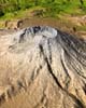 Eugene OR (SPX) Sep 08, 2006
The reason may be counter-intuitive, but the more magma crystallizes, the hotter it gets and the more likely a volcano will erupt, according to a team of scientists that includes a University of Oregon geologist. The knowledge likely will aid monitoring of conditions at Mount St. Helens and other volcanic hot spots around the world. |
|
| The content herein, unless otherwise known to be public domain, are Copyright 1995-2006 - SpaceDaily.AFP and UPI Wire Stories are copyright Agence France-Presse and United Press International. ESA PortalReports are copyright European Space Agency. All NASA sourced material is public domain. Additionalcopyrights may apply in whole or part to other bona fide parties. Advertising does not imply endorsement,agreement or approval of any opinions, statements or information provided by SpaceDaily on any Web page published or hosted by SpaceDaily. Privacy Statement |