| . |  |
. |
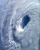
Washington DC (SPX) Jul 27, 2006 Scientists from NASA, the National Oceanic and Atmospheric Administration, universities and international agencies will study how winds and dust conditions from Africa influence the birth of hurricanes in the Atlantic Ocean. The field campaign, called NASA African Monsoon Multidisciplinary Analyses 2006, runs from Aug. 15 to mid-September in the Cape Verde Islands, 350 miles off the coast of Senegal in West Africa. The campaign is a component of a much broader international project, called the African Monsoon Multidisciplinary Analyses, aimed at improving the knowledge and understanding of the West African Monsoon. Researchers will use satellite data, weather station information, computer models and aircraft to provide scientists with better insight into all the conditions that enhance the development of tropical cyclones, the general name given to tropical depressions, storms and hurricanes. The research will help hurricane forecasters better understand the behavior of these deadly storms. "Scientists recognize the hurricane development process when they see it, but our skill in forecasting which weak system will intensify into a major cyclone is not great," said Edward Zipser, of the University of Utah in Salt Lake City, the mission chief scientist. "That is why NASA and its partners place a high priority on obtaining high-quality data for weak disturbances, as well as those already showing signs of intensification," Zipser added. For hurricanes to develop, specific environmental conditions must be present: warm ocean waters, high humidity and favorable atmospheric and upward spiraling wind patterns off the ocean surface. Atlantic hurricanes usually start as weak tropical disturbances off the coast of West Africa and intensify into rotating storms with weak winds, called tropical depressions. If the depression continues to intensify and reaches wind speeds of at least 39 mph, they are classified as tropical storms. Hurricanes have winds greater than 73 miles per hour. To study these environmental conditions, researchers will use NASA's DC-8 research aircraft as a platform for advanced atmospheric research instruments. Remote and on-site sensing devices will allow scientists to target specific areas in developing storms. Sensors on-board the aircraft will measure cloud and particle sizes and shapes, wind speed and direction, rainfall rates, atmospheric temperature, pressure and relative humidity. The campaign will use extensive data from NASA's fleet of earth observing satellites, including the Tropical Rainfall Measurement Mission, QuikSCAT, Aqua, and the recently-launched Cloudsat and CALIPSO. These advanced satellites will provide unprecedented views into the vertical structure of the tropical systems, while the field observations will help validate data from the new satellites. To better understand the physics of hurricanes, researchers are seeking answers to questions about hurricane development, air currents and the effects of dust on clouds. During the field campaign, scientists hope to get a better understanding of the role of the Saharan Air Layer and how its dry air, strong embedded winds and dust influences cyclone development. The layer is a mass of very dry, often dusty air that forms over the Sahara Desert during the late spring, summer, and early fall and usually moves out over the tropical Atlantic Ocean. As part of looking at the Saharan Air Layer, scientists want to better understand dust's effect on clouds. Some evidence indicates that dust makes it more difficult for rain to form. Cloud models need to account for any such effect, so measurements of cloud droplet concentrations and size in clean ocean air and dusty air from the Sahara need to be made. Researchers also will look at what happens to air currents as they move from land to ocean waters. Information on clouds and moisture, heat, air movement, and precipitation in an unstable atmosphere will be collected, analyzed and then simulated in computer models. Understanding hurricane formation requires measurements from very small to very large scales, from microscopic dust and raindrops to cloud formations and air currents spanning hundreds of miles. Related Links NASA hurricane research Bring Order To A World Of Disasters 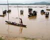 Beijing (AFP) Jul 25, 2006
 Typhoon Kaemi struck the southeast coast of China on Tuesday, sparking the evacuation of more than 700,000 people in an area still reeling from a tropical storm that claimed over 600 lives. |
|
| The content herein, unless otherwise known to be public domain, are Copyright 1995-2006 - SpaceDaily.AFP and UPI Wire Stories are copyright Agence France-Presse and United Press International. ESA PortalReports are copyright European Space Agency. All NASA sourced material is public domain. Additionalcopyrights may apply in whole or part to other bona fide parties. Advertising does not imply endorsement,agreement or approval of any opinions, statements or information provided by SpaceDaily on any Web page published or hosted by SpaceDaily. Privacy Statement |