| . |  |
. |
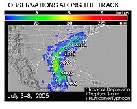
Washington DC (SPX) Apr 26, 2006 Data gathered from last year's NASA hurricane research mission and a NASA satellite have improved tropical storm landfall and storm strength forecasts in computer models. Ocean surface wind data gathered from NASA's QuikSCAT satellite were combined with data from aircraft sensors dropped into tropical storms and fed into a new generation weather research and forecasting (WRF) computer model used to predict weather. The researchers in this study also used data from the National Oceanic and Atmospheric Administration's (NOAA) GOES-11 satellite rapid-scan cloud track wind data. When the data were added, the resulting prediction showed improved track and intensity forecast of tropical storms. "Our results indicate the quite positive impact of those data on forecasts of two landfall storms in last season: tropical storms Cindy and Gert." said Zhaoxia Pu, scientist at the University of Utah, Salt Lake City, and lead researcher on the study. She reported the results on April 24 at the American Meteorological Society�s Conference on Hurricanes and Tropical Meteorology in Monterey, Calif. The detailed results of this study have been submitted to the Monthly Weather Review for publication. "By incorporating the aircraft sensor and QuiKSCAT data, the new generation WRF computer model was able to reproduce structure of the rainfalls that caused the flooding during the landfall of two storms," Pu said. In July 2005, the Tropical Cloud Systems and Processes (TCSP) mission investigated two hurricanes and several tropical storms. The mission was based at the Juan Santamaria Airfield in San Jose, Costa Rica, and flew 13 NASA ER-2 science flights, including missions to Hurricanes Dennis and Emily. NASA, NOAA, and the Costa Rican Centro Nacional de Alta Tecnologia were participants in the mission. The P-3 aircraft from the NOAA Hurricane Research Division flew 20 coordinated missions with the NASA research aircraft to investigate developing tropical disturbances. Sensors dropped from airplanes, called dropsondes, gathered data on temperature, winds, pressure and humidity inside the storms. The team also employed small, unmanned aerial vehicles, a series of balloon-borne weather probes and several low-earth, polar-orbiting and geostationary NASA and NOAA satellites. The results from this study imply that satellite data are a valuable source for improving tropical cyclone forecasts. In addition, the 2005 field experiment provided valuable data and opportunities for better understanding tropical cyclones. The new generation WRF computer model is widely used for forecasting and research. It has been used by many local government agencies, research institutes and commercial industries for real-time forecasts. Pu said that NASA data's enhancement of WRF hurricane computer model forecasts will encourage the forecast community to incorporate it in all future hurricane forecasts. Related Links NASA Hurricane Research Mission  Bucharest (AFP) Apr 25, 2006
A thousand people fled Monday and at least another 9,000 were on stand-by for evacuation in Romania after the swollen River Danube burst its banks. A gap "about 100 metres (yards) long" had opened up after emergency crews tried to plug the barrier about four kilometres from the town of Bistret in Dolj county, said a rescue official, General Vladimir Secara. |
|
| The content herein, unless otherwise known to be public domain, are Copyright 1995-2006 - SpaceDaily.AFP and UPI Wire Stories are copyright Agence France-Presse and United Press International. ESA PortalReports are copyright European Space Agency. All NASA sourced material is public domain. Additionalcopyrights may apply in whole or part to other bona fide parties. Advertising does not imply endorsement,agreement or approval of any opinions, statements or information provided by SpaceDaily on any Web page published or hosted by SpaceDaily. Privacy Statement |