| . |  |
. |
State College, Pa. (UPI) Sep 21, 2010 The southeastern U.S. faces the possibility of being battered by multiple tropical storms or hurricanes next month in what forecasters have dubbed "Troptober." The period starting in late September and into October could yield three to five named tropical systems as the waters of the Gulf of Mexico, Caribbean and the southwestern Atlantic are primed to explode, Accuweather.com reported Tuesday. Forecasters are concerned the raging La Nina and its associated cool waters in the tropical Pacific have created a tremendous imbalance, AccuWeather.com hurricane expert Joe Bastardi said. Computer models seem to support the concern with a barrage of tropical cyclones predicted to form in succession over the Caribbean and the southwestern Atlantic during the last few days of September through the first part in October. If the model-based predictions prove accurate, Florida, part of the Gulf Coast, the southern Atlantic seaboard, Cuba, Hispaniola, Puerto Rico and the Bahamas could be in for multiple rounds of heavy rains, gusty winds, rough seas and battering surf, Accuweather.com said.
earlier related report Parts of the province were on high alert for most of the day as the hurricane approached from the Atlantic Ocean, unleashing fierce winds and torrential rains. Public broadcaster CBC said one person was missing after being swept out to sea near Britannia, on Random Island in Trinity Bay. The man fell into a brook leading to the Atlantic Ocean when a roadway crumbled beneath his feet. Search and rescue efforts were said to be hampered by widespread flooding and washouts of roads. At 1930 GMT, Igor was about 85 kilometers (53 miles) northeast of Newfoundland's capital Saint Johns, and was moving north at 55 kilometers per hour (34 miles per hour), the Canadian Hurricane Centre said. "Heavy rainfall should end this evening as Igor moves off to the northeast ... away from Newfoundland," it said. The storm buffeted eastern Newfoundland, battering the coast with sustained winds of up to 140 kilometers per hours (87 miles per hour) and waves up to six meters (18 feet). Throughout the day, Igor also dumped more than 200 millimeters (eight inches) of rain on parts of the province. "Mother Nature is really giving a pounding to the Burin Peninsula (in southern Newfoundland) right now," Royal Canadian Mounted Police Sergeant Boyd Merrill told CBC. A state of emergency was announced in several coastal towns, forcing their evacuation, while at least one bridge was washed out and many roads were closed, said the provincial transportation ministry. "Hurricane force winds have been observed by an oil rig, buoy data, ship data, and coastal stations near, and offshore of Southeastern Newfoundland," said the Canadian Hurricane Centre, warning that it could still intensify. Extra-tropical cyclones occur outside the tropics, and are distinct from hurricanes in that they generate energy from temperature contrasts between warm and cold air masses. Like Igor, they can still carry hurricane-force winds. Hurricane Igor battered Bermuda on Sunday and Monday with fierce winds and storm surges that flooded its coastlines, flattened palm trees and left most of the island without power. It is expected to weaken as it moves further north of Newfoundland, reaching Baffin Island and Greenland on Saturday. Meanwhile the twelfth named storm of the Atlantic season formed earlier Tuesday west of the Cape Verde Islands. Tropical Storm Lisa was spinning slowly northwestward bearing winds of 75 kilometers (45 miles) per hour, with strengthening expected in the next 48 hours, the NHC said, adding there were no immediate threats to land.
Share This Article With Planet Earth
Related Links Bringing Order To A World Of Disasters When the Earth Quakes A world of storm and tempest
 NASA's Armada Of Research Aircraft Monitor Hurricane Karl
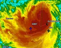
Washington DC (SPX) Sep 21, 2010 NASA's armada of research aircraft arrived at Hurricane Karl on Thursday, Sept. 16. The Global Hawk left southern California at 6 a.m. PDT for a 24-hour roundtrip flight to observe the storm. The DC-8, temporarily based in Ft Lauderdale, Fla., took off at approximately 1 p.m. EDT for about seven hours of research time. The WB-57, based in Houston, Texas, began its six-hour mission at ... read more |
|
| The content herein, unless otherwise known to be public domain, are Copyright 1995-2010 - SpaceDaily. AFP and UPI Wire Stories are copyright Agence France-Presse and United Press International. ESA Portal Reports are copyright European Space Agency. All NASA sourced material is public domain. Additional copyrights may apply in whole or part to other bona fide parties. Advertising does not imply endorsement,agreement or approval of any opinions, statements or information provided by SpaceDaily on any Web page published or hosted by SpaceDaily. Privacy Statement |