| . |  |
. |
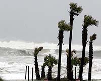
Tallahassee FL (SPX) Oct 10, 2006 When Hurricane Dennis passed North Florida on July 10, 2005, it caused a 10-foot storm surge in some areas along Apalachee Bay -- about 3 to 4 feet more than forecasted-- that couldn't be explained only by the local winds that conventionally drive storm surge. Now, scientists at Florida State University and the National Oceanic and Atmospheric Administration have found that the surge in Apalachee Bay was amplified by a "trapped wave" that originated off the southwest Florida coast. The discovery of this previously undocumented storm surge phenomenon has changed how NOAA's National Hurricane Center prepares storm surge models for the Gulf of Mexico. New modeling procedures will help improve the accuracy of storm surge forecasts for the entire Gulf coast from Florida to Texas. Scientists Steven Morey, Mark Bourassa, Dmitry Dukhovskoy and James O'Brien of FSU's Center for Ocean Atmospheric Prediction Studies and Stephen Baig of NOAA's Tropical Prediction Center of the National Hurricane Center drew their conclusions after conducting numerical experiments with storm surge models. Their research was published in the Oct. 4 issue of the journal Geophysical Research Letters. Hurricane Dennis formed from a tropical depression that originated near the southern Windward Islands on July 4, 2005. It strengthened as it traveled northwest through the Caribbean Sea until it made landfall in Cuba as a Category 4 hurricane. It then traveled west of the Florida Shelf, and the storm's maximum sustained winds weakened to 54 mph before it made landfall on the western Florida Panhandle. "Winds from Dennis forced water against the southwestern Florida coast creating a bulge of high sea level from Naples to around Tampa," Morey explained. "Oceanographers know that this 'bulge' will form a long wave that, in the Northern Hemisphere, will travel as a wave with the coast to the right. Because Dennis traveled nearly parallel to the Florida Peninsula coast at the same speed as the wave, winds from Dennis amplified the wave as it traveled to Apalachee Bay." The trapped wave then piled up on the shore along Apalachee Bay on top of the surge generated by the winds over the bay, according to O'Brien. "To address these findings, we will use as necessary a larger geographical grid in our operational storm surge model in the Gulf of Mexico," said Baig, oceanographer and storm surge leader at NOAA's National Hurricane Center. "This will provide a more comprehensive view of a storm's potential impact in the Gulf by better accounting for the rare trapped wave effect." This type of remotely trapped wave could play a role in future storms that follow a path similar to Hurricane Dennis or travel westward south of the Louisiana coastline toward Texas, the scientists said. Related Links Florida State University A world of storm and tempest Learn about Climate Science at TerraDaily.com  Beijing (XNA) Oct 04, 2006
Typhoon Bebinca, the seventeenth tropical storm of the year, is building up near the Philippines and will affect east Chinese ocean in coming hours, a meteorological report said Tuesday. According to the China Meteorological administration, Bebinca, packing maximum winds of 18 meters per second, was in shape at latitude 16.3 north and longitude 130.7 east by 5 p.m. on Tuesday and is moving north at a speed of 15 kilometers per hour. |
|
| The content herein, unless otherwise known to be public domain, are Copyright 1995-2006 - SpaceDaily.AFP and UPI Wire Stories are copyright Agence France-Presse and United Press International. ESA PortalReports are copyright European Space Agency. All NASA sourced material is public domain. Additionalcopyrights may apply in whole or part to other bona fide parties. Advertising does not imply endorsement,agreement or approval of any opinions, statements or information provided by SpaceDaily on any Web page published or hosted by SpaceDaily. Privacy Statement |