| . |  |
. |
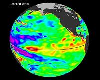
Pasadena CA (JPL) Jun 23, 2010 The latest image of Pacific Ocean sea surface heights from the NASA/European Ocean Surface Topography Mission/Jason-2 oceanography satellite, dated June 11, 2010, shows that the tropical Pacific has switched from warm (red) to cold (blue) during the last few months. The blue area in the center of the image depicts the recent appearance of cold water hugging the equator, which the satellite measures as a region of lower-than-normal sea level. Remnants of the El Nino warm water pool, shown here in red and yellow, still linger north and south of the equator in the center of the image. The image shows sea surface height relative to normal ocean conditions. Red (warmer) areas are about 10 centimeters (4 inches) above normal. Green areas indicate near-normal conditions. Purple (cooler) areas are 14 to 18 centimeters (6 to 7 inches) below normal. Blue areas are 5 to 13 centimeters (2 to 5 inches) below normal. "The central equatorial Pacific Ocean could stay colder than normal into summer and beyond. That's because sea level is already about 10 centimeters [4 inches] below normal, creating a significant deficit of the heat stored in the upper ocean," said JPL oceanographer and climatologist Bill Patzert. "The next few months will reveal if the current cooling trend will eventually evolve into a long-lasting La Nina situation." A La Nina is essentially the opposite of an El Nino. During a La Nina, trade winds in the western equatorial Pacific are stronger than normal, and the cold water that normally exists along the coast of South America extends to the central equatorial Pacific. La Ninas change global weather patterns and are associated with less moisture in the air, resulting in less rain along the coasts of North and South America. They also tend to increase the formation of tropical storms in the Atlantic. "For the American Southwest, La Ninas usually bring a dry winter, not good news for a region that has experienced normal rain and snowpack only once in the past five winters," said Patzert.
Share This Article With Planet Earth
Related Links El Nino, La Nina and Jason-2 Water News - Science, Technology and Politics
 Improved Tracking Of 2010 El Nino Reveals Marine Life Reductions
San Diego CA (SPX) Mar 15, 2010 The ongoing El Nino of 2010 is affecting north Pacific Ocean ecosystems in ways that could affect the West Coast fishing industry, according to scientists at NOAA and Scripps Institution of Oceanography, UC San Diego. Researchers with the California Cooperative Oceanic Fisheries Investigations (CalCOFI) at Scripps and NOAA's Southwest Fisheries Science Center report a stronger than normal ... read more |
|
| The content herein, unless otherwise known to be public domain, are Copyright 1995-2010 - SpaceDaily. AFP and UPI Wire Stories are copyright Agence France-Presse and United Press International. ESA Portal Reports are copyright European Space Agency. All NASA sourced material is public domain. Additional copyrights may apply in whole or part to other bona fide parties. Advertising does not imply endorsement,agreement or approval of any opinions, statements or information provided by SpaceDaily on any Web page published or hosted by SpaceDaily. Privacy Statement |