| . |  |
. |
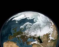
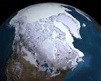
Washington DC (SPX) Jul 17, 2009 Hundreds of images derived from classified data that could be used to better understand rapid loss and transformation of Arctic sea ice should be immediately released and disseminated to the scientific research community, says a new report from the National Research Council. The committee that wrote the report emphasized that these Arctic images show detailed melting and freezing processes and also provide information at scales, locations, and time periods that are important for studying effects of climate change on sea ice and habitat - data that are not available elsewhere. "To prepare for a possibly ice-free Arctic and its subsequent effects on the environment, economy, and national security, it is critical to have accurate projections of changes over the next several decades," said committee chair Stephanie Pfirman, professor and chair of the department of environmental science at Barnard College, New York City. "Forecasts of regional sea-ice conditions can help officials plan for and adapt to the impact of climate change and minimize environmental risks." Projections of future Arctic ice cover are hampered by poor understanding of sea-ice physical processes because few observations exist at appropriate times and scales. Readily available satellite images are too coarse to capture the details, the report says. In addition, collecting ground-based data by maintaining manned-drifting stations is challenging due to rapidly changing environmental conditions and the weak platform of ice, and collecting data from observational aircraft flights is difficult and expensive. "At a time when there is concern that Earth observation systems are decreasing and aging, releasing these images would be a step toward continuing the flow of critical information to the scientific community," said Ralph J. Cicerone, president of the National Academy of Sciences. "We hope that these images are the first of many that could help scientists learn how the changing climate could impact the environment and our society." During the 1990s, a program was started in which scientists recommended collection and archival of high-resolution classified imagery from intelligence sources at environmentally sensitive locations around the globe, with the eventual goal of declassifying and releasing the images to the broader scientific community for research purposes. In 1999, scientists requested that images of sea ice at four locations in the Arctic basin be collected during the summer months; two additional locations were added in 2005. Data have been collected at these sites during the summer months until the present day. In later years of the program, images called Literal Imagery Derived Products (LIDPs) were produced from the classified data at a resolution deemed suitable for unclassified release. To date, several hundred unclassified LIDPs have been produced from the images collected at the six Arctic sites. If these sea-ice LIDPs are publicly released and disseminated to the Arctic research community, scientists could use them in conjunction with available commercial and civilian satellite data to provide new insight into critical physical processes and how these processes are represented in climate models, the committee said. Some of the specific processes that could be explored from the images include the relationship of snow to ice-surface topography, the initiation and development of meltwater ponds in summer, and the relationship of stress and strain and how they are reflected in the pattern of cracks and other features in the ice. Moreover, the report says that the 2007 and 2008 images would greatly enhance the benefits and value of a broad range of intensive ground-based observations carried out during the Fourth International Polar Year (March 2007-March 2009). The summer 2007 sea-ice coverage minimum was a record-breaking low - more than 20 percent below the previous low in 2005 and nearly 40 percent below the 1979-2000 average minimum. Such a dramatic loss of sea ice could be investigated in more detail using the high-resolution imagery. To maximize the fullest potential of the LIDP dataset in scientific research, the committee recommended that the release include thumbnail copies of the images, exact information on the location of the images, calibration information, the time of acquisition, and the information on the pointing angle. Share This Article With Planet Earth
Related Links National Research Council Beyond the Ice Age
 Satellite Survey Reveals Dramatic Arctic Sea-Ice Thinning
Pasadena CA (SPX) Jul 09, 2009 Scientists have evaluated for the first time how much the thickness and volume of Arctic sea ice, not just the ice's surface area, have shrunk since 2004 across the Arctic Ocean basin. Even where the sea ice cover persists despite climate change in the region, a vast portion of the remaining ice layer has become thinner than it used to be, the new study finds. "Even in years when the ... read more |
|
| The content herein, unless otherwise known to be public domain, are Copyright 1995-2009 - SpaceDaily. AFP and UPI Wire Stories are copyright Agence France-Presse and United Press International. ESA Portal Reports are copyright European Space Agency. All NASA sourced material is public domain. Additional copyrights may apply in whole or part to other bona fide parties. Advertising does not imply endorsement,agreement or approval of any opinions, statements or information provided by SpaceDaily on any Web page published or hosted by SpaceDaily. Privacy Statement |
 del.icio.us
 Digg
Digg Reddit
 YahooMyWeb
 Google