| . |  |
. |
|
|
. |
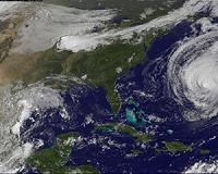
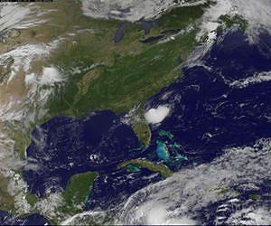
by Staff Writers Greenbelt MD (SPX) Jun 07, 2011
The Hurricane season started June 1, in the Atlantic Ocean and the tropics are paying attention to the calendar. The GOES-13 satellite has been capturing images of a low pressure area that formed off the North Carolina coast yesterday and is now located off of the northeastern Florida coast. The low pressure area, also known as System 93L appears somewhat elongated, almost rounded area of clouds on the satellite imagery, stretching from southwest to northeast. The Geostationary Operational Environmental Satellite called GOES-13 has been capturing imagery of the low since it formed. The visible image from June 1 at 1445 UTC (10:45 a.m. EDT) has some shadows in the middle of the storm, which indicate that there are some towering, strong thunderstorms near the circulation center that are casting shadows onto the lower thunderstorms. NASA's GOES Project, located at NASA's Goddard Space Flight Center, Greenbelt, Md. creates imagery and animations of GOES satellite data. The GOES series of satellites are operated by the National Oceanic and Atmospheric Administration. To see the latest animation of the GOES satellite imagery in "Hurricane Alley" in the Atlantic Ocean visit: and click on "Hurricane Alley HDTV" on the top right side of the NASA GOES webpage. At 8 a.m. EDT, the center of the low was about 200 miles east of Jacksonville, Florida and was moving west-southwest near 20 mph. It is forecast to move over northern Florida later toward the Florida Panhandle. It has a medium chance of becoming the Atlantic hurricane season's first tropical depression in the next 24 hours. The low does mean some scattered strong thunderstorms are in the forecast for northeastern Florida and isolated thunderstorms in southeastern Georgia. The National Weather Service noted that some of the thunderstorms could contain wind gusts to 50 mph, small hail, frequent cloud to ground lightning and heavy rainfall. In addition to the threat of severe thunderstorms, the low is also creating rip currents and building swells along the eastern Florida beaches. For updates, visit NASA's Hurricane Web Page at: www.nasa.gov/hurricane. If the low does intensify into a tropical storm it would receive the name Arlene. However, it must first reach tropical depression status. Even if it doesn't become a depression it still means severe weather for northeastern Florida and southeastern Georgia today.
|
. |
|
| The content herein, unless otherwise known to be public domain, are Copyright 1995-2011 - Space Media Network. AFP and UPI Wire Stories are copyright Agence France-Presse and United Press International. ESA Portal Reports are copyright European Space Agency. All NASA sourced material is public domain. Additional copyrights may apply in whole or part to other bona fide parties. Advertising does not imply endorsement,agreement or approval of any opinions, statements or information provided by Space Media Network on any Web page published or hosted by Space Media Network. Privacy Statement |
 del.icio.us
 Digg
Digg Reddit
 Google