| . |  |
. |
Raleigh NC (SPX) May 19, 2008 A new paper by North Carolina State University archaeologist Dr. Scott Fitzpatrick shows that Ferdinand Magellan's historic circumnavigation of the globe was likely influenced in large part by unusual weather conditions - including what we now know as El Nino - which eased his passage across the Pacific Ocean, but ultimately led him over a thousand miles from his intended destination. Magellan set out from Spain in 1519 with hopes of claiming the wealth of the Spice Islands, or Moluccas, for the Spanish. Two years later the explorer claimed the first European contact with a Pacific island culture when he landed on Guam - 1,500 miles north of the Spice Islands. How did he make it that far" And how did he miss the Spice Islands by that much" The paper, co-authored by Fitzpatrick and University of Calgary researcher Dr. Richard Callaghan, uses computer modeling and historical data to determine the role oceanographic conditions may have played in Magellan's smooth voyage after rounding the notorious Cape Horn at the southernmost tip of South America and in his decision to sail far north of the Spice Islands - which Magellan knew lay along the equator. The paper, "Magellan's Crossing of the Pacific: Using Computer Simulations to Examine Oceanographic Effects on One of the World's Greatest Voyages," was highlighted in the "Random Samples" section of the May 16 issue of Science, and will be published in the Journal of Pacific History in August. The paper concludes that unusually benign weather conditions, likely associated with an El Nino event, allowed Magellan to sail north and may have persuaded him to continue in that direction to avoid starvation - making Magellan's voyage not only the first to circumnavigate the globe, but apparently the earliest historical record of an El Nino event. Specifically, the paper finds that Magellan likely sailed around Cape Horn and directly into the tail end of an El Nino event, resulting in much smoother sailing than would normally have been the case and allowing him to easily sail to the north along the coast of Chile. Fitzpatrick and Callaghan also hypothesize that, after leaving the Chilean coast, Magellan may have chosen to continue on his northerly route in order to take advantage of prevailing winds and currents that had them moving at a good speed and allowed him to rest his sailors, who were by then suffering from scurvy and other maladies. Magellan claimed that he sailed far to the north of the Spice Islands due to concerns that the islands had no food, and Fitzpatrick and Callaghan found some evidence to support this hypothesis. Their paper notes that the Pacific region appears to have been experiencing an El Nino event in 1519 and 1520 - during the bulk of Magellan's voyage - and that an El Nino is often associated with drought and accompanying famines in the area. Community Email This Article Comment On This Article Share This Article With Planet Earth
Related Links North Carolina State University El Nino, La Nina and an Ocean called Pacifica
 Pasadena CA (SPX) Apr 24, 2008
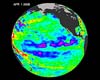
Boosted by the influence of a larger climate event in the Pacific, one of the strongest La Ninas in many years is slowly weakening but continues to blanket the Pacific Ocean near the equator, as shown by new sea-level height data collected by the U.S.-French Jason oceanographic satellite. |
|
| The content herein, unless otherwise known to be public domain, are Copyright 1995-2007 - SpaceDaily.AFP and UPI Wire Stories are copyright Agence France-Presse and United Press International. ESA Portal Reports are copyright European Space Agency. All NASA sourced material is public domain. Additional copyrights may apply in whole or part to other bona fide parties. Advertising does not imply endorsement,agreement or approval of any opinions, statements or information provided by SpaceDaily on any Web page published or hosted by SpaceDaily. Privacy Statement |
 del.icio.us
 Digg
Digg Reddit
 YahooMyWeb
 Google