| . |  |
. |
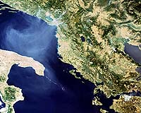
Paris, France (ESA) Jul 31, 2007 Highlighting the extreme weather conditions hitting Europe, space sensors aboard ESA's Envisat satellite have detected the worst floodwaters to hit Britain for 60 years and deadly fires raging through southern Europe. Heavy rains caused the River Thames to burst its banks on Wednesday, forcing the evacuation of hundreds of homes in Britain's university city of Oxford. The flooding across England and Wales has left tens of thousands without electricity and water. The Environment Agency still has three severe flood warnings in place - two on the Thames around Oxford and one on the Ock River near Oxfordshire. In areas where flooding is beginning to recede, sanitation officials are warning of health risks posed by stagnant waters. Flooding is estimated to be the world's most costly kind of natural disaster. The flooding of June and July in the UK is expected to cost the insurance industry at least pound2 billion, according to the Association of British Insurers (ABI). Floods Minister John Healey said recovery and clean-up efforts could take a number of months. One of the biggest problems during flooding emergencies is obtaining an overall view of the phenomenon, with a clear idea of the extent of the flooded area. Aerial observation is often very difficult due to prohibitive weather conditions and, if the phenomenon is widespread, would be very time-consuming and expensive. inundated areas typically visible from space, Earth Observation (EO) is increasingly being used for flood response and mitigation. In October 2000, ESA and the French space agency (CNES) initiated the International Charter on 'Space and Major Disasters', a joint initiative for providing emergency response satellite data free of charge to those affected by disasters anywhere in the world. On 24 July, the UK Environment Agency requested the aid of the Charter.
Heat and fire Fire fighters battled some 1500 blazes within a 24-hour period in parts of central and southern Italy over the weekend. On Tuesday in Italy's southern region of Puglia, thousands of tourists fled to beaches to escape a fast-burning fire and had to be rescued via boats and helicopters. Local media reports two elderly locals were killed trying to escape the flames. On Thursday, fires continued to rage across Calabria and Abruzzo as strong winds thwarted fire-fighting efforts. According to the environmental group WWF, at least 4500 hectares of protected areas have burned in the past three weeks in Italy, with the hardest hit areas being Campania, Abruzzo, Calabria, Sicily and Puglia. Although searing temperatures and tinder dry conditions are to blame for some of the fires, on Wednesday Italian politicians and forestry officials blamed some on arsonists. On Thursday some 200 fires were reported burning across Greece, where temperatures have been as high as 45 C, with more than a dozen burning out of control. Peloponnese and the island of Cephalonia in the Adriatic off the peninsula's northwest coast are among the worst hit areas. Major fires are visible from space - satellites detect not only the smoke billowing from major conflagrations but also the burn scars left in their wake and even the fires themselves - appearing as 'hotspots' when scanning the Earth's surface in infrared wavelengths. For a decade now, ESA satellites have been continuously surveying fires burning across the Earth's surface. Worldwide fire maps based on this data are now available to users online in near-real time through ESA's ATSR World Fire Atlas (WFA). The WFA data are based on results from the Along Track Scanning Radiometer (ATSR) instrument onboard ESA's ERS-2 satellite and the Advanced Along Track Scanning Radiometer (AATSR) onboard Envisat. These twin radiometer sensors work like thermometers in the sky, measuring thermal infrared radiation to take the temperature of Earth's land surfaces.
related report
21 Dead And Hundreds Homeless After Winter Fire Engulfs Forest In South Africa A statement from KZN's provincial government said thousands of pigs, sheep, cows and goats were either burnt alive or had to be put down. Around 320 homes were destroyed in KZN while there was also widespread damage to property in Mpumalanga, although an exact tally has not been compiled. In neighbouring Swaziland, two people were killed as a fire destroyed 80 percent of a thick pine forest, as fires crossed over from South Africa, leaving some 100 people homeless. Heavy winds fanned the flames after an exceptionally dry winter in the north even though areas around Cape Town in the south of South Africa are currently flooded. "We still do not know the actual cause of the fire but we suspect it might be due to the very dry weather conditions in the affected areas," said Mtholephi Mthimkhulu of KZN's agriculture and environmental affairs department. Hundreds of local firefighters who spent the weekend trying to contain the flames are now being supplemented by colleagues from other parts of the country. Food parcels, tents and blankets have been delivered to the worst affected areas as the authorities continue to assess the scale of the damage.
Source: Agence France-Presse Community Email This Article Comment On This Article Related Links Envisat Forest and Wild Fires - News, Science and Technology
 Madrid (AFP) Jul 30, 2007
Firefighters backed by helicopters struggled Sunday to douse major forest fires across southern Europe as special prayers were held in Romania for an end to a deadly heatwave searing the continent. Firefighters staged an uphill battle to extinguish the flames which have ravaged forests in Bulgaria, Macedonia, Greece, as well as Spain's Canary Islands off the western coast of Africa. In Bulgaria, where 23,000 hectares (nearly 57,000 acres) of woodland have been burned in the scorching temperatures of the past week, fires continued to rage in the south and centre. |
|
| The content herein, unless otherwise known to be public domain, are Copyright 1995-2007 - SpaceDaily.AFP and UPI Wire Stories are copyright Agence France-Presse and United Press International. ESA Portal Reports are copyright European Space Agency. All NASA sourced material is public domain. Additional copyrights may apply in whole or part to other bona fide parties. Advertising does not imply endorsement,agreement or approval of any opinions, statements or information provided by SpaceDaily on any Web page published or hosted by SpaceDaily. Privacy Statement |