| . |  |
. |
|
|
. |
by Staff Writers Santo Domingo (AFP) Aug 22, 2011
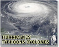
Hurricane Irene raked Puerto Rico and barreled toward Haiti and the Dominican Republic, bringing high winds and rain to that disaster-prone rim of the Caribbean, forecasters said Monday. Irene reached hurricane strength as it passed over Puerto Rico, and at 1500 GMT packed winds of 130 kilometers (80 miles) per hour, the Miami-based US National Hurricane Center said. In Puerto Rico, the first hurricane of the 2011 Atlantic season left 800,000 people without electricity, 118,000 without water and over 770 others in shelters. San Juan, the capital of the densely populated US possession, came within 40 kilometers (25 miles) of the eye of the category one hurricane. Classes were suspended and businesses shuttered in some areas, according to Puerto Rico Governor Luis Fortuno, who announced a state of emergency to mobilize aid from the US Federal Emergency Management Agency. Irene was located about 113 kilometers (70 miles) northeast of Punta Cana in the Dominican Republic, on a track to hit the northern coast of Hispaniola, the island shared by Haiti and the Dominican Republic, in the afternoon or evening. The United States also was bracing for a hit in Florida later in the week, where Irene could make landfall as a category two hurricane on the five-point Saffir-Simpson scale, forecasters said. Irene was expected to strengthen further as it moves west-northwest at around 21 kilometers (13 miles) an hour, according to the NHC. A hurricane warning was in effect for the north coast of the Dominican Republic and Haiti, an impoverished country that was devastated by a catastrophic earthquake in January 2010 that killed an estimated 225,000 people, and then afflicted by a cholera epidemic. All of Haiti was under a tropical storm warning. The Dominican Republic set up 2,364 shelters as it braced for Irene, and ordered that vulnerable areas be evacuated and classes be suspended. A red alert -- the highest -- was issued for 23 provinces and the capital, while the other eight provinces were placed under yellow, or intermediate alert. "We are ready for the storm and are taking our precautions," said presidential spokesman Rafael Nunez. The government gave instructions for over two million food rations to be distributed to soup kitchens, and ordered that small and medium vessels remain in port. Haiti dodged a weather disaster earlier this month when it was brushed by Tropical Storm Emily, but Irene revived fears for the 300,000 people still living in makeshift camps. In the Haitian capital, the US embassy announced that the naval hospital ship USNS Comfort, which arrived in Port-au-Prince on Thursday, would be forced to cease operations and seek safe haven due to the forecast. Haiti was the ship's final port of call at the end of a five-month humanitarian aid mission in Latin America and the Caribbean. The storm was forecast to track northwest toward the Bahamas and Florida coast, with hurricane conditions expected for the southeastern and central Bahamas by late Tuesday. Irene was expected to dump up an additional five to 10 centimeters (two to four inches) of rain across Puerto Rico and the Virgin Islands, with up to 15 centimeters (six inches) over most of northern Hispaniola and up to 25 centimeters (10 inches) over higher terrain. Up to 25 centimeters of rainfall were also expected in the southeastern Bahamas and the Turks and Caicos Islands. "These rains could cause life-threatening flash floods and mudslides in areas of steep terrain," the US center said. A storm surge accompanied by "large and dangerous waves" was also forecast to raise water levels by up to 1.2 meters (four feet) above normal tide levels along the Dominican coast, and up to 1.8 meters (six feet) over the southeastern Bahamas and Turks and Caicos Islands. Further south, Harvey dissipated over the Sierra Madre mountain range in Mexico after driving across southern Mexico with high winds and rain in tow, and striking the coast of Belize on Saturday and lashing Guatemala as a tropical storm. But the remnants of the storm still posed a threat of flash floods and mudslides in some areas.
|
. |
|
| The content herein, unless otherwise known to be public domain, are Copyright 1995-2011 - Space Media Network. AFP and UPI Wire Stories are copyright Agence France-Presse and United Press International. ESA Portal Reports are copyright European Space Agency. All NASA sourced material is public domain. Additional copyrights may apply in whole or part to other bona fide parties. Advertising does not imply endorsement,agreement or approval of any opinions, statements or information provided by Space Media Network on any Web page published or hosted by Space Media Network. Privacy Statement |

 del.icio.us
 Digg
Digg Reddit
 Google