| . |  |
. |
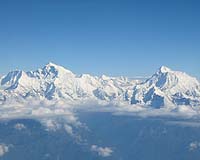
Rochester NY (SPX) Jan 27, 2006 Two new studies by a University of Rochester researcher show that mountain ranges rise to their height in as little as two million years - several times faster than geologists have always thought. Each of the findings came from two pioneering methods of measuring ancient mountain elevations, and the results are in tight agreement. The research papers, appearing in today's issue of Science and next week's issue of Earth and Planetary Science Letters, mean scientists will have to re-evaluate tectonic processes that build high elevation plateaus, such as those in Tibet and the central Andes. "These results really change the paradigm of understanding of how mountain belts grow," says Carmala Garzione, assistant professor of earth and environmental sciences and co-author of both papers. "We've always assumed that the folding and faulting in the upper crust produced high elevation mountains. Now we have data on ancient mountain elevation that shows something else is responsible for the mountains' uplift." Garzione took a new approach to paleoaltimetry, the tricky science of measuring mountain height from the distant past. As mountains lift, weather erodes them, complicating the estimation of how high they might be at any given time. Until Garzione's research, geologists estimated surface uplift by examining leaf fossils to determine at what elevation the plants lived, or by dating when certain minerals began moving rapidly to the surface. Unfortunately, plant characteristics can change radically over millions of years, and changes in climate can also cause erosion, throwing a significant question mark into the equation. Garzione instead focused on the products of that erosion. As mountains are eroded, their sediment is carried down the slope in streams and collected at the base of the forming mountain range. As a mountain range rises, it experiences different atmospheric conditions simply due to its change in height. Those atmospheric changes, such as temperature and the amount and composition of rainfall are recorded in minerals that grow near the surface at different altitudes on the mountainside. Garzione wrote her doctoral dissertation on the possibility of retrieving that atmospheric information from the ancient sediment, dating it, and forming a record of a mountain belt's uplift history. Garzione's recent work concentrated on the Bolivian Altiplano, which is a large, high elevation basin in the Andes Mountains in South America. There she took samples of sedimentary rock that had accumulated between 12 million and 5 million years ago from erosion of the surrounding ranges. One type of mineral, carbonate, precipitates from surface water, so the composition of the carbonate is a good indicator of the composition of rainfall. The composition of rainwater changes with altitude. More than 99 percent of the oxygen in water is made up of oxygen-16 and less than 1 percent of oxygen-18. As vapor rises to higher altitudes in the form of clouds, oxygen-18 is removed from the cloud in rainfall, leaving the cloud more and more depleted in the isotope. This change locks into the minerals that formed at the surface from rainwater. These minerals accumulated in sedimentary basins in Bolivia over millions of years to become the rock strata Garzione sampled. The second method looked at the same Bolivian sediment, but focused on the temperature at which the surface-forming carbonates were created. Atmosphere once again played a key role since air temperature decreases with altitude, meaning a temperature-based recording of the rocks' original altitude should be preserved. Garzione, along with Prosenjit Ghosh and John M. Eiler of the California Institute of Technology, employed a technique developed at CalTech that looks at the abundance of oxygen-18 and carbon-13 that are bonded together. At high temperatures, such as the warm climate at low elevations in the Andes, individual atoms will vibrate vigorously and their bonds to other atoms will break more easily. Because heavy isotope bonds are stronger, at lower temperatures and lower vibrational frequencies, the light isotope bonds are more likely to be broken. Using the CalTech measuring method, Garzione and the CalTech team gauged the temperature at which the carbonates formed--from the hot Amazonian jungle climate to the freezing peaks of the Andes. Both studies yielded the same results: between 10 million and 7 million years ago, the Andes shot up. "When I first showed this data to others, they had a hard time believing that mountains could pop up so quickly," says Garzione. "With supporting data from the new paleotemperature technique, we have more confidence in the uplift history and can determine processes that caused the mountains to rise." If the Andes rose a dramatic kilometer per million years as the studies suggest, scientists can now assign a very specific--and very controversial--process to their uplift. "Deblobbing" may not sound like a very scientific word, but it's the term given to a dense root beneath the Earth's crust--a blob--that becomes unstable and begins to flow downward into the earth's mantle under the force of its own mass, until it detaches. When two tectonic plates collide, such as the Nazca oceanic plate in the southeastern Pacific colliding with the South American continental plate, the continental plate usually begins to buckle. Floating on a liquid mantle, the plates press together and the buckling creates the first swell of a mountain range. Below the crust, however, there also is a kind of buckling going on in the solid portion of the upper mantle. This dense mantle root clings to the underside of the crust, growing in step with the burgeoning mountains above. This dense root acts like an anchor, weighing down the whole range and preventing it from rising, much like a fishing weight on a small bobber holds the bobber low in the water. In the case of the Andes, they swelled to a height of about one kilometer before the mantle root beneath them disconnected and sunk into the liquid mantle. The effect was like cutting the line to the fishing weight--the mountains suddenly "bobbed" high above the surrounding crust, and in less than 3 million years, they had lifted from one kilometer to roughly four. This process had been proposed since the early 1980s, but it has never stood up to scrutiny because these techniques to estimate surface elevation have only been recently developed. "People have largely ignored the role of the mantle lithosphere because it is difficult to look 50 to 200 kilometers into the earth; whereas we can easily see the deformation on the surface." says Garzione. "Some geologists have guessed that the mantle lithosphere is removed continuously and evenly during mountain building. Our data argue that the mantle just accumulates down there until some critical moment when it becomes unstable and drops off." Scientists can use earthquakes to measure the way that seismic waves travel through the Earth, turning a quake into a kind of planetary-scale ultrasound imager. Using this method, geologists believe there may be sizeable blobs of mantle lithosphere sinking beneath the Sierra Nevada mountains, though it could take millions of years for them to detach. Related Links University of Rochester  Bhuj, India (AFP) Jan 25, 2006
While India celebrates Republic Day on Thursday, for many in western Gujarat state the date will bring back terrifying memories of an earthquake which struck with savage force five years ago. |
|
| The content herein, unless otherwise known to be public domain, are Copyright 1995-2006 - SpaceDaily.AFP and UPI Wire Stories are copyright Agence France-Presse and United Press International. ESA PortalReports are copyright European Space Agency. All NASA sourced material is public domain. Additionalcopyrights may apply in whole or part to other bona fide parties. Advertising does not imply endorsement,agreement or approval of any opinions, statements or information provided by SpaceDaily on any Web page published or hosted by SpaceDaily. Privacy Statement |