| . |  |
. |
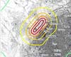
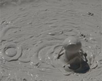
Washington DC (SPX) Aug 01, 2008 A linear string of mud pots and mud volcanoes suggest surface evidence for a southern extension of the San Andreas Fault that runs through the Salton Sea, according to a paper published in the August issue of the Bulletin of the Seismological Society of America (BSSA). Researchers David K. Lynch and Kenneth W. Hudnut of USGS report the results of a comprehensive survey of mud pots in the area immediately east of the southeastern-most portion of the Salton Sea in Imperial County, Calif. Using satellite imagery, followed by a physical examination of the land, they identified a cluster of 33 mud pots, mud volcanoes and sink holes which, when plotted, form a clear linear pattern. Mud pots and mud volcanoes are geothermal features produced when water or gas is forced upward through soil and sediments. Mud pots can assume a variety of forms, typically being depressions or enclosed basins containing gas seeps, bubbling water or viscous mud. Mud pots can also be water-laden and appear as bubbling muddy water. Mud volcanoes, on the other hand, are elevated conical structures composed of accumulations of viscous mud extruded from a central vent. They range from finger-sized to several kilometers across, though the largest in the Salton Sea area are about 2 meters high. Small mud volcanoes on land, ranging from one to 10 feet in height, are usually called mud cones or gryphons and are usually associated with volcanic and seismic activity. "The presence of a linear field of geothermal features is evidence of a planar rift extending to considerable depth in the crust," Lynch and Hudnut write. While geologists have suspected that the San Andreas Fault extended beyond its confirmed terminal point near Bombay Beach, erosion, seismic inactivity and agricultural reshaping of the land have erased any previously identifiable surface evidence to support the theory. The San Andreas Fault is a plate boundary separating Pacific and North American plates. "This new evidence indicates that the region is more complicated than we previously thought," Lynch said. "The extension of the San Andreas does not appear to be active. It is probably a very old part of the fault, and helps to explain the larger, more complex transition area between the Imperial fault and San Andreas fault, called the Brawley Seismic Zone." The southern portion of the San Andreas Fault is the focus of the Great Southern California ShakeOut, which will be an earthquake drill on 13 Nov. 2008 designed to help prepare local citizens for the next very large earthquake. The scenario will call for a quake with a magnitude of 7.8 that begins in the same area that is the subject of this paper. Community Email This Article Comment On This Article Share This Article With Planet Earth
Related Links Seismological Society of America Tectonic Science and News
 Paris (AFP) July 9, 2008
Scientists in the United States have devised a method for measuring changes in the speed of seismic waves that could one day help predict earthquakes, a study said Wednesday. |
|
| The content herein, unless otherwise known to be public domain, are Copyright 1995-2007 - SpaceDaily.AFP and UPI Wire Stories are copyright Agence France-Presse and United Press International. ESA Portal Reports are copyright European Space Agency. All NASA sourced material is public domain. Additional copyrights may apply in whole or part to other bona fide parties. Advertising does not imply endorsement,agreement or approval of any opinions, statements or information provided by SpaceDaily on any Web page published or hosted by SpaceDaily. Privacy Statement |
 del.icio.us
 Digg
Digg Reddit
 YahooMyWeb
 Google