| . |  |
. |
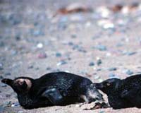
Seattle WA (SPX) Aug 08, 2007 You could understand if a half-dozen Magellanic penguins developed a "big bird is watching" phobia before this month is over, but the surveillance really will be for their own good. University of Washington scientists will attach satellite tracking devices to the backs of six penguins that have been treated at two centers in northern Argentina after their feathers were fouled with oil. The birds will be released into the Atlantic Ocean and their movements traced using satellites and the Internet. The idea is to plug a critical gap in the knowledge of the Magellanics' annual life cycle, their movements on the journey from their winter feeding grounds back to their breeding colonies along the southern Argentina coast and the Islas Malvinas, or Falkland Islands. "We're missing that information. We know what happens when they leave the breeding grounds but we don't know what happens on the return trip," said Elizabeth Skewgar, a University of Washington doctoral student in biology. "We want to model the energy requirements for these birds so that we understand what it takes to return to the breeding grounds and still have enough energy to reproduce. Human fisheries competing for the same food could make migration even more difficult for them." The project is led by Dee Boersma, a UW biology professor who for 25 years has headed the Magellanic Penguin Project at Punta Tombo, Argentina, the birds' largest breeding colony in South America. "We need to know how penguins use the ocean so we can make their migration route safe through a combination of national marine parks, marine protected areas and ocean zoning," Boersma said. During the week of Aug. 20, the scientists will select six adult male penguins from rehabilitation centers at San Clemente del Tuyu and Mar del Plata, coastal towns more than 500 miles north of Punta Tombo. Epoxy and special tape will be used to attach a transmitter to each bird before it is released into the Atlantic. The tags are about the size of many common cellular telephones and weigh less than 3.5 ounces. "We want to put the transmitters on healthy, robust birds that we think are likely to get back and start breeding," Boersma said. "The point is to follow them back to their colony and see where they might be running into petroleum." Through late October the birds' movements will be tracked by the Argos satellite system, operated by the National Oceanic and Atmospheric Administration and the French space agency. A satellite will pass overhead every two hours and chart the penguins' positions, then transmit the information back to the researchers, who will use it to update a public tracking map on the Internet at http://www.penguinstudies.org. The transmitters will be active for 36 hours at a time and then will be off for 36 hours, a means of preserving the two double-A batteries in each transmitter for the life of the project. The researchers have no way of knowing whether the birds will go to southern Argentina or the Malvinas, or whether they will follow a straight course to the breeding grounds or take a circuitous route. "After we release them, they could just hang out at Mar del Plata for a month. It's all up to them," Boersma said. "We're hoping the males we tag will be in a hurry to get to their colony and start breeding." The satellite tracking also will be instrumental in pinpointing the birds after they arrive at the breeding grounds. Punta Tombo alone is home to some 400,000 penguins during breeding season. "Tracking the locations by satellite is only accurate to within 5 kilometers, so it really is like trying to find a needle in a haystack," Boersma said. Locating the penguins once they reach the breeding ground is important so the researchers can assess the birds' physical condition after the long journey. "We'll know how much weight they gained or lost on their journey," Boersma said. After its mate arrives, a male fasts until the female lays two eggs, then he returns to the ocean to feed, sometimes swimming hundreds of miles in search of fish such as anchovies that are staples of the penguin diet. After about two weeks the male returns to the nest to incubate the eggs while the female goes in search of food. The birds' energy can be drastically sapped if they become coated with oil, and that can mean death. Last year, a team of scientists that included Boersma reported they had found 19 groups rehabilitating oiled seabirds along the Atlantic coast from central Brazil to central Argentina, indicating a much larger problem than generally had been believed. It remains uncertain where the oil comes from -- it could be from a combination of sources, including seepage from offshore oil rigs and ballast water from passing ships. "We know that birds show up oiled back at our colony, so that means they're getting oiled somewhere between where they winter and Punta Tombo," Boersma said. Others involved in the work are Sergio Rodriguez Heredia of the Fundacion Mundo Marino in San Clemente del Tuyu, Karen Griot of Fundacion Mar del Plata Aquarium and Valeria Ruoppolo of the International Fund for Animal Welfare's Penguin Network. Community Email This Article Comment On This Article Related Links University of Washington Earth Observation News - Suppiliers, Technology and Application
 Boulder CO (SPX) Aug 08, 2007
On July 3, a NASA aircraft equipped with a state-of-the-art sensor provided emergency response officials with critical soil moisture data for several regions across Texas that were threatened by flooding. NASA responded to the heavy rains and flooding in Texas by redirecting a NASA research aircraft, the P-3B, to Texas after it completed an interagency project in Oklahoma. The aircraft had been flying a sensor developed by the University of Colorado at Boulder, NOAA and U.S. Department of Agriculture that could provide detailed maps of ground surface water. |
|
| The content herein, unless otherwise known to be public domain, are Copyright 1995-2007 - SpaceDaily.AFP and UPI Wire Stories are copyright Agence France-Presse and United Press International. ESA Portal Reports are copyright European Space Agency. All NASA sourced material is public domain. Additional copyrights may apply in whole or part to other bona fide parties. Advertising does not imply endorsement,agreement or approval of any opinions, statements or information provided by SpaceDaily on any Web page published or hosted by SpaceDaily. Privacy Statement |