| . |  |
. |
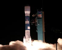
Washington (AFP) June 20, 2008 A French-US satellite, which will provide the most accurate monitoring ever of rising sea levels and track the effects of climate change, was launched into orbit Friday from California. A Delta 2 rocket carrying the Jason 2 satellite took off from Vandenberg Air Force base at 0746 GMT. "All indications are that Jason 2 is operating," said NASA launch manager Omar Baez. The rocket sent an explosive arc of light into the night sky, some 160 miles (256 kilometers) northwest of Los Angeles, as it launched the satellite on a three-year journey to track virtually the entire oceanic surface of Earth and extend the record of sea-level study from space to two decades. The 1,124-pound (510-kilogram) space lab is designed to provide precise monitoring of rising sea levels and currents, which are among the most serious consequences of global warming, threatening dozens of island nations and highly populated delta regions especially in Asia and Africa. Improved technology will allow Jason 2 to achieve a sea-level measurement accuracy of within 2.5 centimeters (one inch), compared with 3.3 centimeters (1.3 inches) for its predecessor Jason 1, NASA said. Data from previous missions showed that sea levels have risen on average by 0.3 centimeters per year since 1993, or twice as much as they did in the whole of the 20th century, according to marine measurements. But 15 years of data is not enough to draw accurate long-term conclusions, say scientists. The latest mission will help create the first multi-decade global record of the role of the ocean in climate change, according to scientists at NASA's Jet Propulsion Laboratory in Pasadena, California. It will also provide more accurate forecasts of seasonal weather patterns, and near real-time data on ocean conditions. "Without this data record, we would have no basis for evaluating change," said the mission's project scientist, Lee-Lueng Fu, in a statement. Fu compared the sea level record begun in 1992 with the continuous measurements of atmospheric carbon dioxide initiated in the 1950s at the Mauna Loa Observatory in Hawaii. "The Mauna Loa data proved that carbon dioxide levels were indeed rising as had been predicted, and they were the basis for our understanding of the greenhouse effect," Fu said. "The height of the ocean is another fundamental measurement of our climate. The key is to have rigorous, well-calibrated data collected over a long period of time." The oceans, major storehouses for heat from the sun, act as the planet's thermostat. They absorb more than 80 percent of the heat from global warming, with the rest absorbed by the atmosphere, land and glaciers, NASA scientists have found. Warming water and melting ice are the two main factors contributing to rising sea levels. The satellite will map the surface of 95 percent of Earth's ice-free oceans every 10 days. It will also provide more accurate forecasts of seasonal weather patterns, and near real-time data on ocean conditions. The OSTM/Jason 2 mission is a partnership between the US space agency NASA, the US National Oceanic and Atmospheric Administration, the French National Center of Space Studies (CNES) and the European satellite agency EUMETSAT. Fifty-five minutes after lift-off, the rocket separated from the spacecraft as Jason 2 reached its orbit of some 830 miles (1,335 kilometers) above the Earth. NASA TV provided a unique view of the separation, with a mounted camera beaming back live pictures of the satellite slowly drifting away into the void. "It was a beautiful picture from the 'rocket-cam'," launch manager Baez said. The satellite then deployed its solar panels and oriented them toward the Sun to charge its batteries ahead of a series of instrumental tests. Community Email This Article Comment On This Article Share This Article With Planet Earth
Related Links Water News - Science, Technology and Politics
 Livermore CA (SPX) Jun 20, 2008
New research suggests that ocean temperature and associated sea level increases between 1961 and 2003 were 50 percent larger than estimated in the 2007 Intergovernmental Panel on Climate Change report. |
|
| The content herein, unless otherwise known to be public domain, are Copyright 1995-2007 - SpaceDaily.AFP and UPI Wire Stories are copyright Agence France-Presse and United Press International. ESA Portal Reports are copyright European Space Agency. All NASA sourced material is public domain. Additional copyrights may apply in whole or part to other bona fide parties. Advertising does not imply endorsement,agreement or approval of any opinions, statements or information provided by SpaceDaily on any Web page published or hosted by SpaceDaily. Privacy Statement |
 del.icio.us
 Digg
Digg Reddit
 YahooMyWeb
 Google