| . |  |
. |
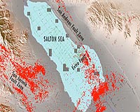
San Diego CA (SPX) Jul 29, 2009 New research by a team of scientists from Scripps Institution of Oceanography at UC San Diego and the U.S. Geological Survey (USGS) offers new insight into the San Andreas Fault as it extends beneath Southern California's Salton Sea. The team discovered a series of prominent faults beneath the sea, which transfer motion away from the San Andreas Fault as it disappears beneath the Salton Sea. The study provides new understanding of the intricate earthquake faults system beneath the sea and what role it may play in the earthquake cycle along the southern San Andreas Fault. "The stretch of the San Andreas Fault that extends into the Salton Sea is an important part of the overall fault system but it remains poorly understood," said Danny Brothers, a Scripps graduate student and lead author on the study. "Our results provide crucial information on how deformation is transferred from the San Andreas Fault to the Imperial Fault and how young basins along strike-slip faults, such as the Salton Sea, evolve through time." In a study published in the July 26 early online edition of the journal Nature Geoscience, the Scripps-led research team including Brothers, Neal Driscoll, Graham Kent, Alistair Harding, Jeff Babcock and Rob Baskin, from the USGS, used geophysical methods to image the faults beneath the Salton Sea. This study offers new information on the location of faults and how they communicate tectonic deformation with neighboring faults located onshore. The Salton Sea is flanked by two major faults - the San Andreas and San Jacinto - and recent studies have revealed that the region has experienced magnitude-7 earthquakes roughly every 200 years for the last thousand years. Previous studies conducted by researchers at San Diego State University and Cal Tech indicate that it has been approximately 300 years since the last rupture. "We discovered a series of prominent faults near Bombay Beach during pilot studies in 2006 and 2007, and went on to survey the area more comprehensively in 2008 and 2009," researchers stated in the journal's "backstory" commentary section. The highlight of the expedition was when the team discovered the first previously unknown fault in the Salton Sea, just miles offshore from Bombay Beach, Calif. The research team used a high-resolution seismic imaging technique, known as CHIRP, to image the layers of sediments beneath the lake that have been offset by the motion of faults. Scripps' Neal Driscoll developed the digital CHIRP profiler to provide high-quality imagery of the sediments below oceans and lakes to offer a comprehensive view of underwater faults. Funding for the research study was provided by the California Department of Water Resources, California Department of Fish and Game, UC San Diego Academic Senate, Scripps Institution of Oceanography at UC San Diego, National Science Foundation and Southern California Earthquake Center. Share This Article With Planet Earth
Related Links Scripps Institution of Oceanography Bringing Order To A World Of Disasters When the Earth Quakes A world of storm and tempest
 Invisibility Cloak Could Protect Against Earthquakes
Liverpool UK (SPX) Jul 23, 2009 Research at the University of Liverpool has shown it is possible to develop an 'invisibility cloak' to protect buildings from earthquakes. The seismic waves produced by earthquakes include body waves which travel through the earth and surface waves which travel across it. The new technology controls the path of surface waves which are the most damaging and responsible for much of the destr ... read more |
|
| The content herein, unless otherwise known to be public domain, are Copyright 1995-2009 - SpaceDaily. AFP and UPI Wire Stories are copyright Agence France-Presse and United Press International. ESA Portal Reports are copyright European Space Agency. All NASA sourced material is public domain. Additional copyrights may apply in whole or part to other bona fide parties. Advertising does not imply endorsement,agreement or approval of any opinions, statements or information provided by SpaceDaily on any Web page published or hosted by SpaceDaily. Privacy Statement |
 del.icio.us
 Digg
Digg Reddit
 YahooMyWeb
 Google