| . |  |
. |
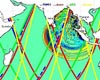
Jakarta, Indonesia (SPX) Nov 18, 2008 On 11 November 2008, almost four years after the devastating tsunami catastrophe, President Susilo Bambang Yudhoyono of Indonesia inaugurated the InaTEWS tsunami early warning system (Indonesian Tsunami Early Warning System) in the Indonesian capital Jakarta. Germany has made a significant contribution to this system. The German Remote Sensing Data Center (Deutsches Fernerkundungsdatenzentrum; DFD) of the German Aerospace Center (Deutsches Zentrum fur Luft- und Raumfahrt; DLR) has developed and put in place a Decision Support System (DSS) for InaTEWS, which will enable significantly improved tsunami early warning for the Indian Ocean. Germany has been prominently involved in setting up this system in the context of the German Indonesian Tsunami Early Warning System (GITEWS). The propagation times of tsunamis in Indonesia are very short due to the geological conditions in the region. This means that a tsunami early warning is only useful when it is generated quickly and automatically. DLR's Decision Support System (DSS) will help to make this possible. Quick and effective evacuation of people out of the affected coastal areas before catastrophe strikes is equally important. DLR therefore also performed a risk assessment, investigating the possible consequences of a tsunami impact on the co ast. This assessment provides important groundwork for preliminary measures in vulnerable areas and for evacuation planning. In order to make tsunami advance warning even more reliable in the future, DLR also investigated new Earth observation technologies while developing the DSS. This research is also important for enabling transfer of the early warning system to other areas vulnerable to tsunamis, such as the Mediterranean. "I am pleased that DLR was able to bring its years of experience and its expertise in Earth observation and crisis information to this technologically sophisticated project, thereby contributing to its success," said Professor Johann-Dietrich Worner, Chairman of the DLR Executive Board. "One of the most pressing tasks for space research is to use all available technological resources in order to protect life on Earth."
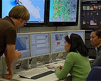
Tsunami early warning and decision support Staff of the early warning centre in Jakarta is able to get an overview of the situation based on the available information. An up-to-date situation report and proposed actions are generated on the basis of continually refreshed information and improved constantly through an interactive process. The situation report and proposed actions will be clearly displayed on multiple monitors When the decision is taken to issue a warning, the provinces that are at risk as well as the competent authorities are alerted using several means of communication - such as radio, fax and text message - at the same time. The DSS is specially tailored for use in crisis situations. Its user interface and process sequences have been designed in such a way as to allow staff to take decisions quickly and reliably, even under high time pressure and stressful conditions. The system's multiple redundancy makes it highly reliable. Its databases not only contain extensive geographic datasets, but also risk information and hazard maps pre-processed by DLR. All these elements add up to a system which is unique in the world, both conceptually and in terms of its complexity.
Two years of testing and optimising So far, several individual components of the system have already been put to use in the provisional warning centre in Jakarta. Over the past few weeks, a new building has been completed, the required communication and computer hardware has been integrated into the system, and all software components have been installed. This means that the system as originally conceived is now available for the first time. GITEWS is a joint project of DLR, the Alfred Wegener Institute for Polar and Marine Research (Alfred-Wegener-Institut fur Polar- und Meeresforschung; AWI) in Bremerhaven, the Federal Institute for Geosciences and Natural Resources (Bundesanstalt fur Geowissenschaften und Rohstoffe; BGR) in Hannover, the Deutsche Gesellschaft fur Technische Zusammenarbeit (GTZ) in Eschborn, the GKSS Research Centre (GKSS Forschungszentrum) in Geesthacht, the German Marine Research Consortium (Konsortium Deutsche Meeresforschung; KDM) in Berlin, the Leibniz Institute for Marine Sciences (Leibniz-Institut fur Meereswissenschaften; IFM-GEOMAR) in Kiel, and the Institute for Environment and Human Security of the United Nations University (UNU-EHS) in Bonn. The project is led by the German Research Centre for Geosciences (Deutsches GeoForschungszentrum; GFZ) in Potsdam. GITEWS was funded by the German federal government through the Federal Ministry of Education and Research (Bundesministeriums fur Bildung und Forschung; BMBF). Share This Article With Planet Earth
Related Links DLR Bringing Order To A World Of Disasters When the Earth Quakes A world of storm and tempest
 Paris (AFP) Oct 29, 2008
A massive Indian Ocean tsunami, similar in size to the behemoth that claimed a quarter of a million lives in December 2004, smashed into Thailand and Indonesia around 600 years ago, scientists believe. |
|
| The content herein, unless otherwise known to be public domain, are Copyright 1995-2007 - SpaceDaily.AFP and UPI Wire Stories are copyright Agence France-Presse and United Press International. ESA Portal Reports are copyright European Space Agency. All NASA sourced material is public domain. Additional copyrights may apply in whole or part to other bona fide parties. Advertising does not imply endorsement,agreement or approval of any opinions, statements or information provided by SpaceDaily on any Web page published or hosted by SpaceDaily. Privacy Statement |
 del.icio.us
 Digg
Digg Reddit
 YahooMyWeb
 Google