| . |  |
. |
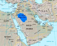
Paris (AFP) Oct 22, 2008 The UN Educational, Scientific and Cultural Organisation (UNESCO) on Wednesday published the first global map of cross-border aquifers with the aim of helping management of a precious and often-threatened resource. The inventory comprises 273 aquifers that straddle internal or international boundaries. Aquifers are sponge-like underground rock that hold water. They exist on all continents but some, such as those in in North Africa, the Arabian peninsula and the western United States, were formed more than 10,000 years ago when the climate was more humid and are no longer being replenished. Burgeoning populations and extensive irrigation are fuelling concerns for these aquifers and some experts fear the risk of future "water wars" between rival states. The map can be accessed on (http://www.whymap.org/nn_354300/whymap/EN/Downloads/Global__maps/globalmaps__node__en.html?__nnn=true). Community Email This Article Comment On This Article Share This Article With Planet Earth
Related Links Water News - Science, Technology and Politics
 Madison WI (SPX) Oct 22, 2008
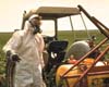
The widespread use of pesticides across the United States has been in practice for decades, with little knowledge of the long-term effects on the nation's groundwater. |
|
| The content herein, unless otherwise known to be public domain, are Copyright 1995-2007 - SpaceDaily.AFP and UPI Wire Stories are copyright Agence France-Presse and United Press International. ESA Portal Reports are copyright European Space Agency. All NASA sourced material is public domain. Additional copyrights may apply in whole or part to other bona fide parties. Advertising does not imply endorsement,agreement or approval of any opinions, statements or information provided by SpaceDaily on any Web page published or hosted by SpaceDaily. Privacy Statement |
 del.icio.us
 Digg
Digg Reddit
 YahooMyWeb
 Google