| . |  |
. |
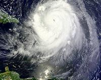
Miami (AFP) Aug 31, 2010 Hurricane Earl churned toward the US mainland Tuesday, posing a threat to a big beach holiday weekend over a vast section of the eastern seaboard after pummeling several Caribbean islands with heavy winds and rain. A hurricane watch was issued for the North Carolina coast, the National Hurricane Center said, calling Earl a "large and intense" storm. Earl remained a strong category four hurricane with fierce winds of up to 135 miles (215 kilometers) an hour, moving to the northwest at 14 miles (22 kilometers) per hour). At 0000 GMT it was centered 125 miles (235 kilometers) east of Grand Turk Island on the Turks and Caicos and 835 miles (1,545 kilometers) southeast of Cape Hatteras, North Carolina. A hurricane watch, which means there is potential for hurricane-force winds to hit the area, was posted for an area from Surf City to Duck in North Carolina. US officials were keeping a cautious eye on the storm warning as evacuation plans may have to be put in place in some coastal areas. The White House said President Barack Obama would consult the head of the US Federal Emergency Management Agency Craig Fugate on Wednesday morning to discuss preparations being made in the United States for the arrival of the storm. The powerful storm brushed past Puerto Rico Tuesday and steamed northwest towards the Bahamas on a path that may hit the eastern US seaboard. Tropical storm warnings were in effect for the Turks and Caicos and a tropical storm watch for the southeastern Bahamas. If the forecasts are accurate, Earl could trigger dangerous waves and surf in the United States, wrecking plans for vacationers for the upcoming Labor Day weekend on a large portion of the east coast. "Impacts on the coast of the Carolinas will begin with waves late in the day tomorrow and then Friday further up the coast," said Bill Read, the director of the National Hurricane Center. Earl comes on the heels of Hurricane Danielle, blamed for rough surf and riptides in New York and New Jersey last weekend. The forecast track suggests Earl could unleash strong winds on parts of North Carolina's tourist spot of the Outer Banks and whirl up the coastline towards New England and Canada. "If Earl continues its present course, it will batter the Outer Banks of North Carolina Thursday and Cape Cod Friday night with strong winds, powerful waves and potential flooding problems," said Accuweather meteorologist Alex Sosnowski. Sosnowski said the storm track was still uncertain but left open the possibility of winds near hurricane force on the Outer Banks. "Waves of up to 20 feet (six meters) may batter the region, leading to beach erosion and overwash of roads and structures," he said. Fugate urged residents along the coast to take precautions, and said evacuation warnings may be sounded. "Although the decision to evacuate might be made by local officials, today is the day to make sure you have your family disaster plans, that you check your supplies," he said in a teleconference. Earl damaged homes, downed trees, blocked roads and snapped power lines in the Caribbean, including the French islands of Saint Martin and Saint Barthelemy, where thousands of people were left without power. In Saint Martin, French Overseas Minister Marie-Luce Penchard expressed "great solidarity" with residents of the French island. She said the storm, which clipped the Caribbean island as it churned north, inflicted damage to the country's airport, where dozens of meters (yards) of fencing had been ripped from the ground by strong winds. Earl was whipping up massive waves as it continued its arc past Puerto Rico and Hispaniola, which includes the Dominican Republic and Haiti. "We were quite fortunate because there was no direct hit in this case," Puerto Rico Governor Luis Fortuno told CNN. He said about 174,000 people lost power and 33,000 were left without water. On the five-point Saffir-Simpson scale used by the NHC, a category four storm carries a warning that "catastrophic damage will occur," with a high risk of structural damage if it hits land. Meanwhile, Tropical Storm Fiona was moving westward in the wake of Earl at 20 miles (33 kilometers) per hour, and centered some 300 miles (485 kilometers) east of the Leeward Islands. Packing top winds of 40 miles (65 kilometers) per hour, Fiona was expected to skim the islands late Tuesday or early Wednesday. Tropical storm watches and warnings were issued for several islands.
Share This Article With Planet Earth
Related Links Bringing Order To A World Of Disasters When the Earth Quakes A world of storm and tempest
 Puerto Rico, Virgin isles brace for Hurricane Earl
San Juan, Puerto Rico (AFP) Aug 30, 2010 Powerful Hurricane Earl bore down on Puerto Rico and the neighboring Virgin Islands Monday, growing in strength as forecasters warned it could bring dangerous waves and flash floods. Earl was raised to a category three "major hurricane" early Monday packing winds of up to 120 miles (195 kilometers) an hour, weather experts said, as thousands were left without power in nearby French islands h ... read more |
|
| The content herein, unless otherwise known to be public domain, are Copyright 1995-2010 - SpaceDaily. AFP and UPI Wire Stories are copyright Agence France-Presse and United Press International. ESA Portal Reports are copyright European Space Agency. All NASA sourced material is public domain. Additional copyrights may apply in whole or part to other bona fide parties. Advertising does not imply endorsement,agreement or approval of any opinions, statements or information provided by SpaceDaily on any Web page published or hosted by SpaceDaily. Privacy Statement |